Newport
About Newport |
Storm Surge History |
|
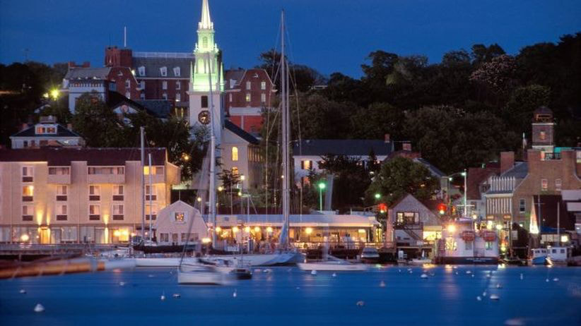
Newport is a famous New England coastal hot spot thanks to it's rich history and scenic location. The city is located 30 miles south of the capital city of Providence, at the southern end of Aquidneck Island in Narragansett Bay. This coastal community is 11 square miles in size and is surrounded by Atlantic coastline on the city's east, west, and southern borders. This lively seaport was once a capital for while-oil trade, colonial culture, and American history. Today, Newport is home to high-end tourism, summer recreation, and historic mansions. Rhode Island's principal tourist center reported that Newport is visited annually by approximately 3.5 million tourists. This area is home to many beaches, public and private, and most popular attractions include the Newport Cliff Walk, the St. Patrick's day parade, the Tennis Hall of Fame, and America’s Cup sailing competition.
|
Like many coastal communities in New England, Newport's seaward location makes it vulnerable to storm surge from both hurricanes and nor'easters. This historic seaport is highly developed and surrounded by coastline, which contributes to the city's long history of expensive and reoccurring flood events. Between 1930-2017, over 60 major storm surge events have been recorded into the Newport's U-Surge dataset. Newport experiences high frequency (low magnitude) surge events from winter storms (nor'easters) and low frequency (high magnitude) storm surges from hurricanes. It is uncommon for Newport to experience a 8ft water level above MSL. The 1938 hurricane generated the highest water level on record, which reached 12.99 ft above MSL. Sea level rise projections suggest Newport's 100-year flood level could increase from 10.65ft to16.5ft (above MSL) by year 2100.
|
Infographics
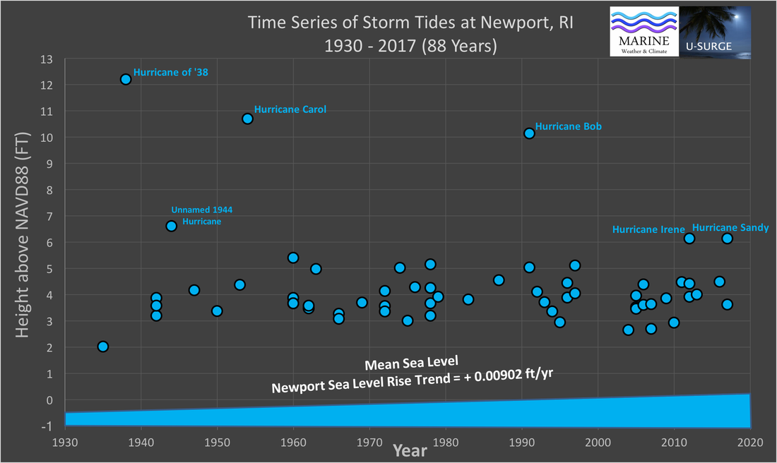
This time series provides maximum water levels from 61 recorded storm tide events at Newport, RI since 1930. These events are ordered chronologically from oldest (left) to newest (right). The numerous low-magnitude events in recent decades are influenced by both climate and data availability. All data are converted to NAVD88 datum, however, the data are intentionally not detrended, so the influence of relative sea level rise (SLR) is included. SLR trend taken from NOAA tide gauge at Newport.
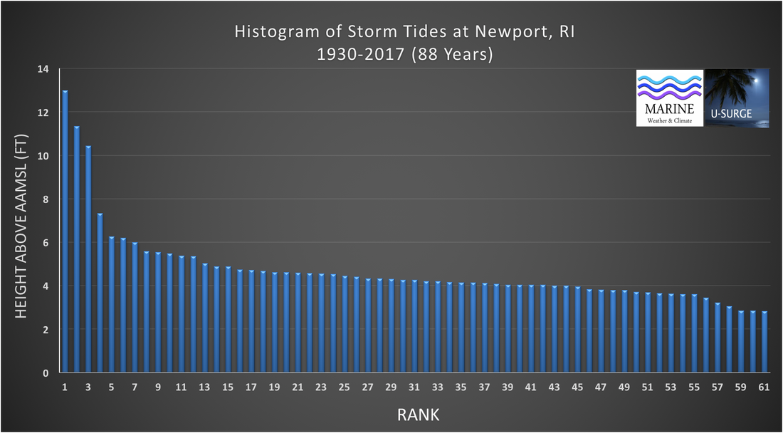
This histogram provides the maximum water levels of the 61 storm tide events at Newport, RI since 1930. The events are ordered from the highest water level (Rank=1) to lowest (Rank=61). These events are not placed in chronological order. All data are detrended to remove the influence of relative sea level rise, so they represent water levels above an Annually-Adjusted Mean Sea Level (AAMSL).
Statistics/ Return Period
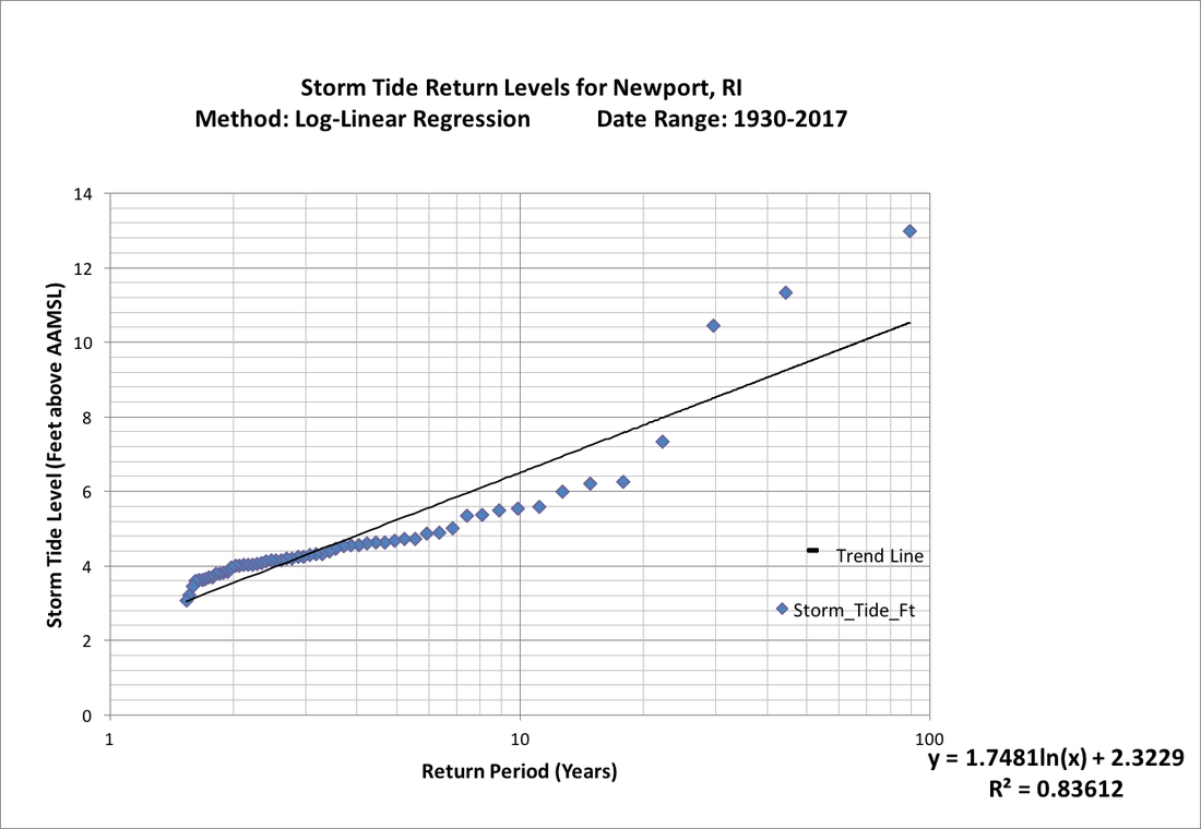
Storm tide return levels graph for Newport. This graph uses a log-linear regression plot based on observed data from 1930-2017 (88 years). This analysis is conducted on the 61 storm tide events that are greater than or equal to 3.0 feet above the Annually-Adjusted Mean Sea Level (AAMSL). These data have been detrended to remove the influence of sea level rise.
Return Period |
Storm Tide Level (Feet above AAMSL) |
500-yr |
13.19 |
200-yr |
11.59 |
100-yr |
10.38 |
50-yr |
9.16 |
25-yr |
7.95 |
10-yr |
6.35 |
Extreme water levels above Annually-Adjusted Mean Sea Level (AAMSL) with long-term sea level rise removed. The correct way to interpret these levels is as follows: Based on a log-linear regression of observed data from 1930-2017, storm tide levels at Newport should equal or exceed 10.37 ft every 100 years, on average, above the annually-adjusted MSL. According to the regression equation, the 12.987ft storm tide generated by the Hurricane of '38 was a 445-year event.
Sea-Level Rise and Future Extreme Water Levels
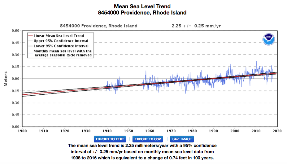
Long-term SLR graph for Providence, Rhode Island. The long-term rate of SLR is 0.74 feet/century.
Source: https://tidesandcurrents.noaa.gov/sltrends/sltrends_station.shtml?stnid=8779770.
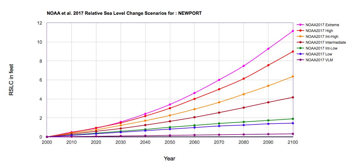
Graph of SLR scenarios for Newport, Rhode Island, from NOAA et al. (2017). The CorpsClimate web-tool developed by U.S. Army Corps of Engineers provided this graph. Data revised July 18, 2017. Available on the Web at: http://corpsclimate.us/ccaceslcurves.cfm.
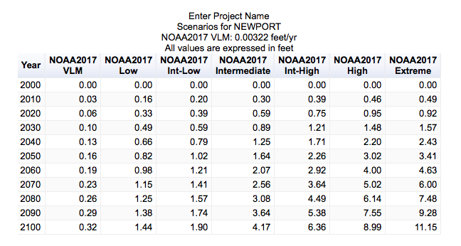
Table of SLR scenarios for Newport, Rhode Island, from CorpsClimate web-tool developed by U.S. Army Corps of Engineers. Data from this table revised July 18, 2017. Available on the Web at: http://corpsclimate.us/ccaceslcurves.cfm.
Year |
Intermediate SLR |
Intermediate-High SLR |
2000 |
10.14 |
10.14 |
2020 |
10.73 |
10.89 |
2040 |
11.39 |
11.85 |
2060 |
12.21 |
13.06 |
2080 |
13.22 |
14.63 |
2100 |
14.31 |
16.5 |
This table provides future 100-year water levels above NAVD88 for Newport, RI. These numbers are calculated by adding three values: 1) The 100-year storm tide listed in the Statistics/ Return Period section 2) Projected SLR from the Future Table in the Sea Level Rise section 3) An adjustment in water level above NAVD88 between the year 2000 and the mean year of the Current Epoch for datum analysis. For Newport, Rhode Island, that mean year is 1992 and the water level adjustment is 0.072 feet, based on a long-term SLR rate of 2.75 cm/yr shown in Past Graph in the Sea Level Rise section.
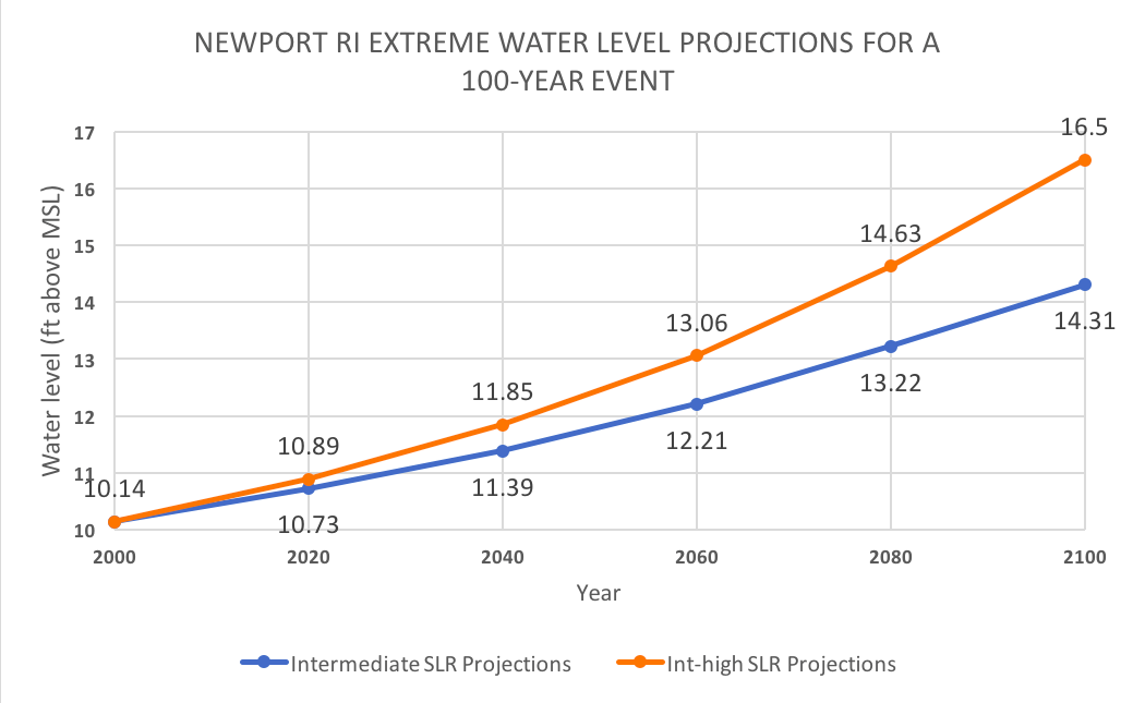
This graph is a visual representation of the changing water levels associated with a Newport 100-year storm, including the effects of sea levels rise. This provides future 100-year water levels above NAVD88. These numbers are calculated by adding three values: 1) The 100-year storm tide listed in the Statistics/ Return Period section 2) Projected SLR from the Future Table in the Sea Level Rise section 3) An adjustment in water level above NAVD88 between the year 2000 and the mean year of the Current Epoch for datum analysis. For Newport, Rhode Island, that mean year is 1992 and the water level adjustment is 0.074 feet, based on a long-term SLR rate of 2.75 cm/yr shown in Past Graph in the Sea Level Rise section.
Storm Surge Data Sources
|
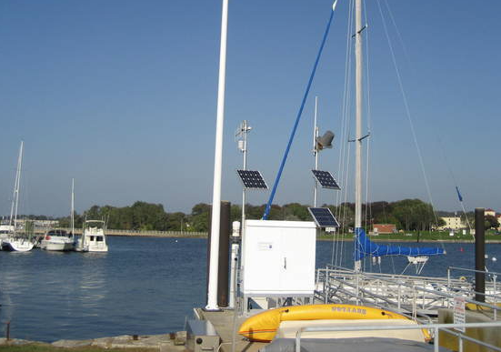
Tide Gauge Site: Newport, RI 8452660
Operation: National Ocean Service (NOS) Coordinates: Latitude 41.5033 N, Longitude 71.3267 W 6-min Water Level Data Nov 1, 1995 - Present Hourly Water Level Data Sep 10, 1930 - Aug 31, 1954 Jun 14, 1955 - Present |
|
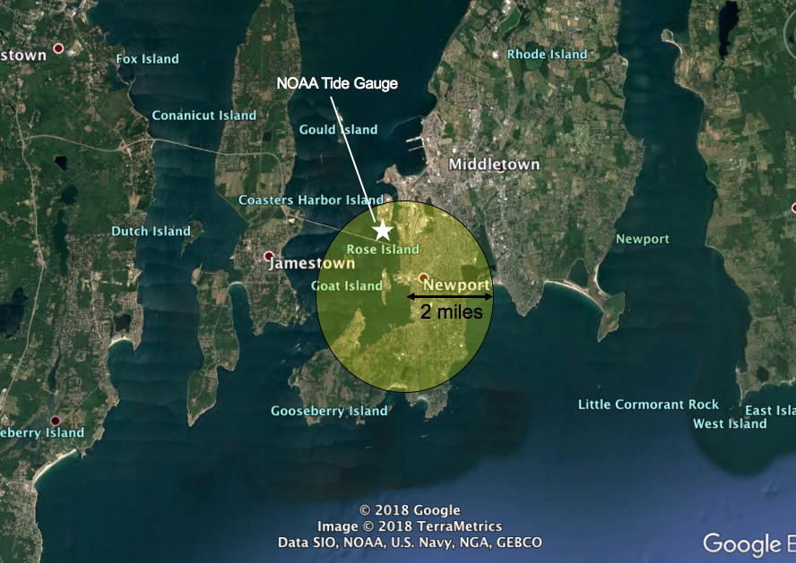
Flood data for Newport are taken from a circular area with a 2-mile radius, centered on 41.4844N, -71.3173W. This area contains downtown Newport, Newport Harbor and a NOAA tide gauge that has provided data since 1930.
Missing Data
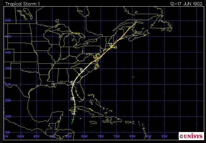
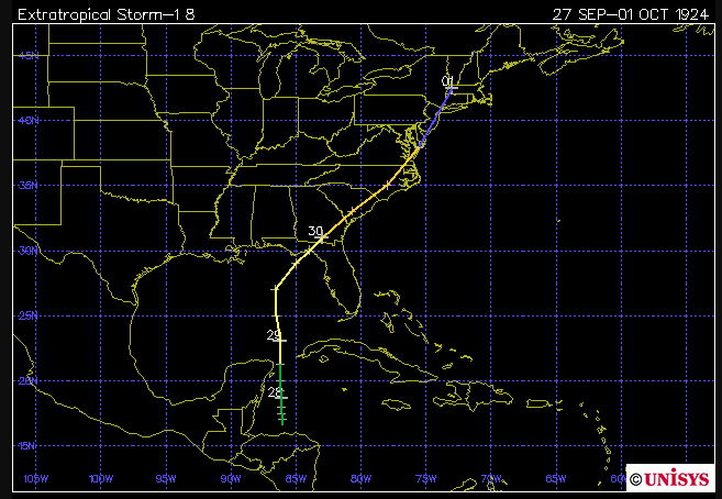
We have identified five hurricanes since 1900 that may have generated storm tides exceeding 2ft near Newoprt, but a literature review does not yet provide data. These maps are provided by Unisys Corporation
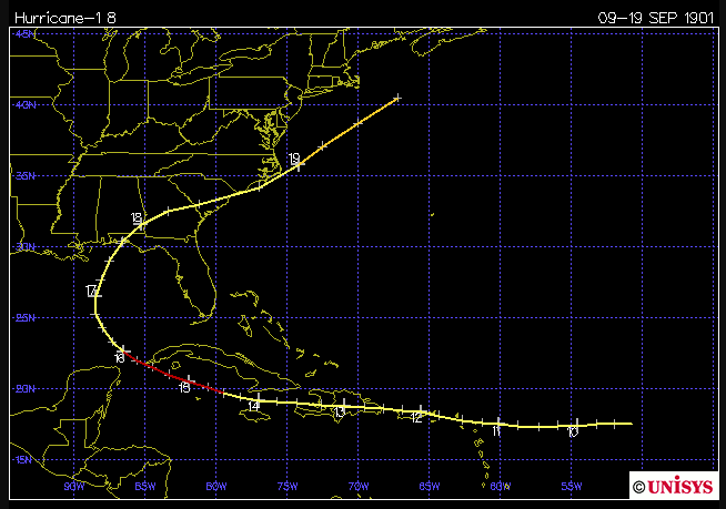
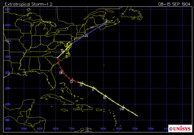
September 14th - November 26th, 1938
August 31st, 1954 - June 10th, 1955
October 3rd, 1971 - October 13th 1971
(tidesandcurrents.noaa.gov)
Storm Surge Multimedia
Local Partnership
Newport U-Surge Team
Caroline Salvaneschi - Graduate Student, University of Rhode Island
Vanessa Anderson - Graduate Student, University of Rhode Island
Austin Becker, Ph.D. - Assistant Professor of Coastal Planning, Policy, and Design, University of Rhode Island
Hal Needham, Ph.D. - Founder and President, Marine Weather and Climate
Newport Restoration Foundation supported the U-Surge project as part of its climate change and cultural heritage initiative, Keeping History Above Water™. Read below for more information on this initiative and Newport Restoration Foundation.
About Keeping History Above Water™
The first edition of Keeping History Above Water: Newport was organized by the Newport Restoration Foundation in April 2016 to address the challenges posed to historic buildings and neighborhoods from sea level rise and increasing storm activity. The conference emphasized practical approaches to protecting historic built environments in both the near and long term, at individual building, infrastructure, and policy levels. Keeping History Above Water: Newport featured an international slate of panelists with expertise in climate science, a wide range of knowledge in heritage preservation, and experience in community organizing around this increasingly urgent global concern. Newport Restoration Foundation has an ongoing interest in advancing knowledge related to sea level rise, not just in Newport, but in other historic coastal communities across the country. NRF’s intent is to see Keeping History Above Water continue to advance public understanding and develop solutions through traveling each year to other vulnerable communities facing similar threats, expanding the conversation nationally and globally. For more information on Keeping History Above Water, visit www.HistoryAboveWater.org.
Keeping History Above Water™ is on Twitter @histabovewater and Facebook /historyabovewater.
About Newport Restoration Foundation
The Newport Restoration Foundation (NRF) is a non-profit organization founded in 1968 by Doris Duke to preserve, maintain, and interpret Newport, Rhode Island's 18th- and early 19th-century architectural heritage. In addition to a collection of more than 75 historic houses, now rented to tenant-stewards, NRF operates three museum properties: Rough Point, Doris Duke's Newport mansion, which is home to a significant collection of European and Asian fine and decorative arts; Whitehorne House Museum, featuring a collection of 18th-century Newport furniture and related decorative arts (closed to the public in 2018 while we plan for revitalization); and Prescott Farm, a public park and historic site in Middletown, Rhode Island, with gardens maintained by the University of Rhode Island Master Gardeners program. The foundation is actively engaged in historic preservation, public programming, and scholarly research. For more information, please visit www.NewportRestoration.org.
NRF is on Twitter @NPTRestoration, Facebook /NPTRestoration and Instagram @NPTRestoration.
NRF's media contact is Meaghan Barry. Email: meaghan@newportrestoration.org
University of Rhode Island Research Group:
Professor Austin Becker
Caroline Salvaneschi
Vanessa Anderson
Professor Austin Becker
Caroline Salvaneschi
Vanessa Anderson