U-SURGE
  • Home
  • About
  • U.S. Cities
    • US Atlantic Coast (North) >
      • Rhode Island >
        • Newport
        • Providence
      • Massachusetts >
        • Boston
      • Connecticut >
        • New London/ Groton
      • New Jersey >
        • Cape May
        • Atlantic_City
        • Sandy Hook/ North Jersey
      • New York >
        • New York City
    • U.S. Gulf Coast >
      • Texas >
        • South Padre Island
        • Corpus Christi
      • Mississippi
      • Alabama
      • Florida
  • Contact


Gulfport/ Biloxi

Picture

About Gulfport/ Biloxi

Coming Soon....

Storm Surge History

Coming Soon...


Map of Highest Surge Event

Picture
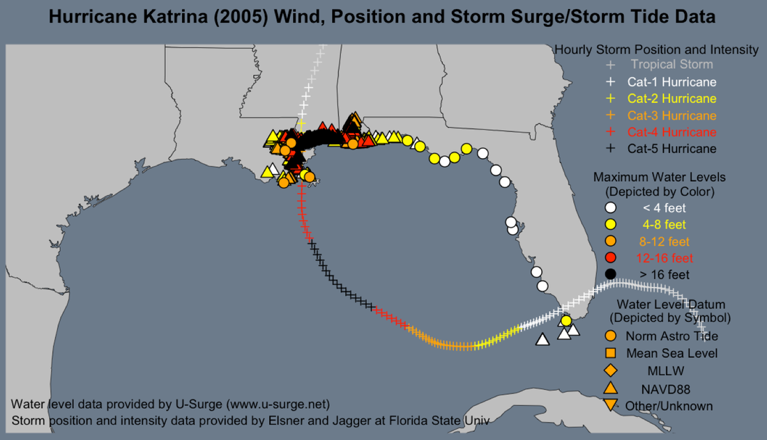
Hurricane Katrina inundated the North-Central U.S. Gulf Coast with record water levels.  Katrina generated the highest water level on record for six urban locations in the region: Shell Beach and Slidell, Louisiana, Bay St. Louis/Pass Christian and Gulfport/Biloxi, Mississippi, as well as Dauphin Island and Mobile, Alabama.


​Multi-Media
​

Hurricane Isaac (2012)


​Hurricane Katrina (2005)

© 2017 Marine Weather & Climate. All rights reserved.
  • Home
  • About
  • U.S. Cities
    • US Atlantic Coast (North) >
      • Rhode Island >
        • Newport
        • Providence
      • Massachusetts >
        • Boston
      • Connecticut >
        • New London/ Groton
      • New Jersey >
        • Cape May
        • Atlantic_City
        • Sandy Hook/ North Jersey
      • New York >
        • New York City
    • U.S. Gulf Coast >
      • Texas >
        • South Padre Island
        • Corpus Christi
      • Mississippi
      • Alabama
      • Florida
  • Contact