Hurricane Dorian
Radar image/ loops courtesy of Brian McNoldy- University of Miami
Hurricane Dorian Update
Wed Sep 04 0500PM EDT
IMPORTANT EVENING UPDATE WITH DAMAGE UPGRADES
HURRICANE DORIAN - WED SEP 04 0500PM EDT
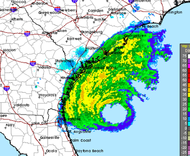
As of Wed Sep 04 at 0500PM EDT, the National Hurricane Center provided Hurricane Dorian's center of circulation at 150 south of Charleston, SC.
Maximum sustained winds have increased to 110 mph, putting Dorian at the upper threshold of a category-2 hurricane. At 111 mph+, hurricanes are classified as "major hurricanes" and become category 3 on the Saffir Simpson Hurricane Wind Scale.
Hurricane force winds (74 mph+) extended up to 70 miles from the center, and tropical storm force winds (39 mph+) extended up to 175 miles from the center. You can see the eye clearly visible on the snapshot from Brian McNoldy's radar loop (around 7PM EDT).
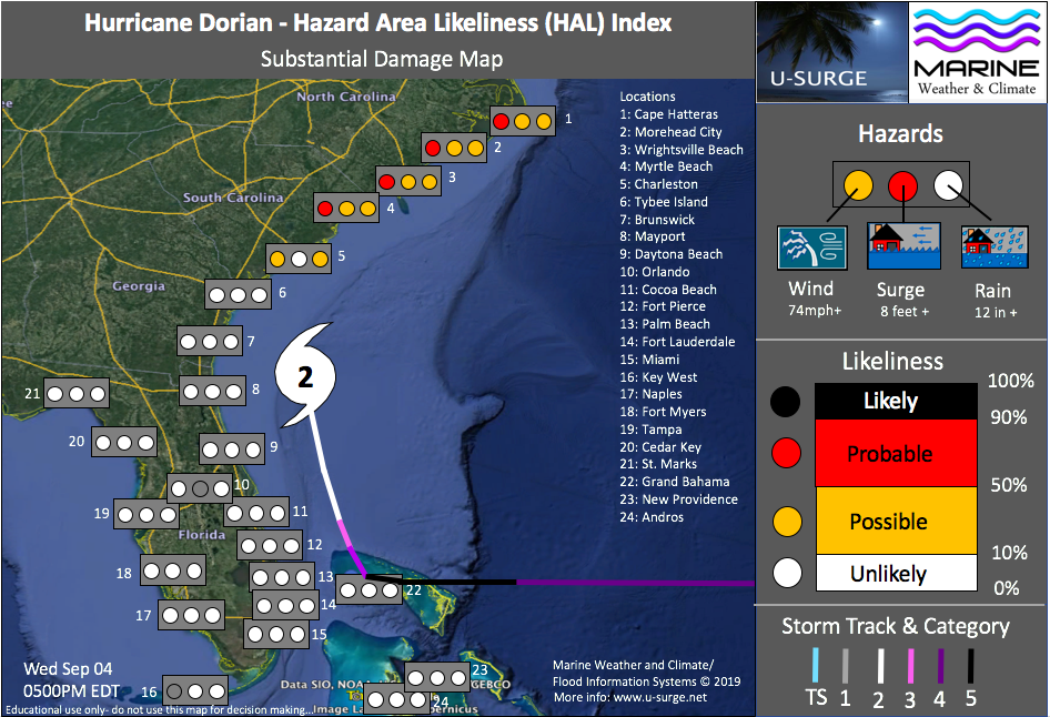
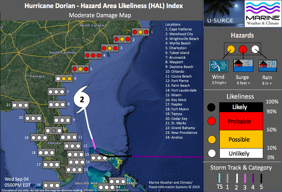
Important evening upgrades to the Hazard Area Likeliness (HAL) Map:
Due to a slight westward shift in the track, the following hazard risks have been upgraded...
The likeliness of substantial wind damage at Myrtle Beach, Wrightsville Beach, Morehead City and Cape Hatteras has been upgraded to PROBABLE (it was previously POSSIBLE);
The likeliness of substantial storm surge damage at Myrtle Beach, Wrightsville Beach, Morehead City and Cape Hatteras has been upgraded to POSSIBLE (it was previously UNLIKELY);
The following hazards have been downgraded...
The likeliness of substantial flood damage from rain has been downgraded to UNLIKELY at Tybee Island (it was previously POSSIBLE);
The likeliness of moderate wind damage at Tybee Island, Brunswick and Mayport has been downgraded to UNLIKELY (it was previously POSSIBLE);
The likeliness of moderate storm surge flooding at Brunswick and Mayport has been downgraded to UNLIKELY (it was previously POSSIBLE);
We have kept the risk of moderate storm surge flooding at Tybee Island as POSSIBLE. Storm surge levels are holding around 3 feet above Normal Astronomical Tide (NAT) this evening, and it is possible that water levels could continue rising until winds shift offshore;
The likeliness of moderate flooding from rain has been downgraded to UNLIKELY at Mayport and Brunswick (it was previously POSSIBLE);
Dorian is forecast to take a nearly shore-parallel track along the South Carolina coast...a slight change in the position could mean the difference between a direct landfall and the storm center staying offshore.
High tides generally occur around 1PM and 1AM for many coastal locations in South Carolina now...with low tides occurring around 7AM and 7PM. Many locations will observe peak storm tides (total water levels) during early Thursday afternoon.
It is possible that Dorian will slightly strengthen, making it a category-3 / major hurricane. Regardless of this possibility, expect Dorian to inflict life-threatening wind and flood hazards, especially along the coasts of South Carolina and North Carolina.
Stay safe everyone and have a great night!
-Hurricane Hal
HURRICANE DORIAN - WED SEP 04 0500PM EDT
As of Wed Sep 04 at 0500PM EDT, the National Hurricane Center provided Hurricane Dorian's center of circulation at 150 south of Charleston, SC.
Maximum sustained winds have increased to 110 mph, putting Dorian at the upper threshold of a category-2 hurricane. At 111 mph+, hurricanes are classified as "major hurricanes" and become category 3 on the Saffir Simpson Hurricane Wind Scale.
Hurricane force winds (74 mph+) extended up to 70 miles from the center, and tropical storm force winds (39 mph+) extended up to 175 miles from the center. You can see the eye clearly visible on the snapshot from Brian McNoldy's radar loop (around 7PM EDT).
Important evening upgrades to the Hazard Area Likeliness (HAL) Map:
Due to a slight westward shift in the track, the following hazard risks have been upgraded...
The likeliness of substantial wind damage at Myrtle Beach, Wrightsville Beach, Morehead City and Cape Hatteras has been upgraded to PROBABLE (it was previously POSSIBLE);
The likeliness of substantial storm surge damage at Myrtle Beach, Wrightsville Beach, Morehead City and Cape Hatteras has been upgraded to POSSIBLE (it was previously UNLIKELY);
The following hazards have been downgraded...
The likeliness of substantial flood damage from rain has been downgraded to UNLIKELY at Tybee Island (it was previously POSSIBLE);
The likeliness of moderate wind damage at Tybee Island, Brunswick and Mayport has been downgraded to UNLIKELY (it was previously POSSIBLE);
The likeliness of moderate storm surge flooding at Brunswick and Mayport has been downgraded to UNLIKELY (it was previously POSSIBLE);
We have kept the risk of moderate storm surge flooding at Tybee Island as POSSIBLE. Storm surge levels are holding around 3 feet above Normal Astronomical Tide (NAT) this evening, and it is possible that water levels could continue rising until winds shift offshore;
The likeliness of moderate flooding from rain has been downgraded to UNLIKELY at Mayport and Brunswick (it was previously POSSIBLE);
Dorian is forecast to take a nearly shore-parallel track along the South Carolina coast...a slight change in the position could mean the difference between a direct landfall and the storm center staying offshore.
High tides generally occur around 1PM and 1AM for many coastal locations in South Carolina now...with low tides occurring around 7AM and 7PM. Many locations will observe peak storm tides (total water levels) during early Thursday afternoon.
It is possible that Dorian will slightly strengthen, making it a category-3 / major hurricane. Regardless of this possibility, expect Dorian to inflict life-threatening wind and flood hazards, especially along the coasts of South Carolina and North Carolina.
Stay safe everyone and have a great night!
-Hurricane Hal
Hazard Area Likeliness (HAL) Index
Likeliness of Substantial Damage from Wind, Storm Surge and Rainfall Flooding Updated Wed Sep 04 0500PM EDT
Likeliness of Moderate Damage from Wind, Storm Surge and Rainfall Flooding
Updated Wed Sep 04 0500PM EDT
Press Release
FOR IMMEDIATE RELEASE --
SUN SEP 01, 2019
Marine Weather and Climate, The U-Surge Project, and Flood Information Systems have launched the place-based Hazard Area Likeliness (HAL) Map in anticipation of Hurricane Dorian.
This map provides the likeliness of substantial and moderate damage from wind, storm surge and heavy rainfall flooding for 24 cities from North Carolina to the Florida Gulf Coast, including three sites in the Bahamas.
Such maps are crucial, as hurricanes inflict wind and flood hazards across a broad area, regardless of the exact track of the eye. Prediction of hurricane flooding is particularly important, as many people perceive hurricanes as exclusively wind hazards, yet floods cause 88% of hurricane-related fatalities.
These maps will be updated regularly as Dorian approaches the U.S. Coast.
For more information about the HAL Index/ Map, and for regular updates, bookmark the U-Surge Hurricane Dorian page at: https://www.u-surge.net/hurricane-dorian.html
About the Hazard Area Likeliness (HAL) Map/ Index
- Wind probability adapted from National Hurricane Center advisories;
- Rain probability adapted from National Hurricane Center graphics, Quantitative Precipitation Forecast (QPF) maps, and model output from Euro and GFS models;
-Storm surge probability estimated from U-Surge, which serves as the U.S. Storm Surge Database, and potentially SLOSH model output.
Peak Storm Surge Map
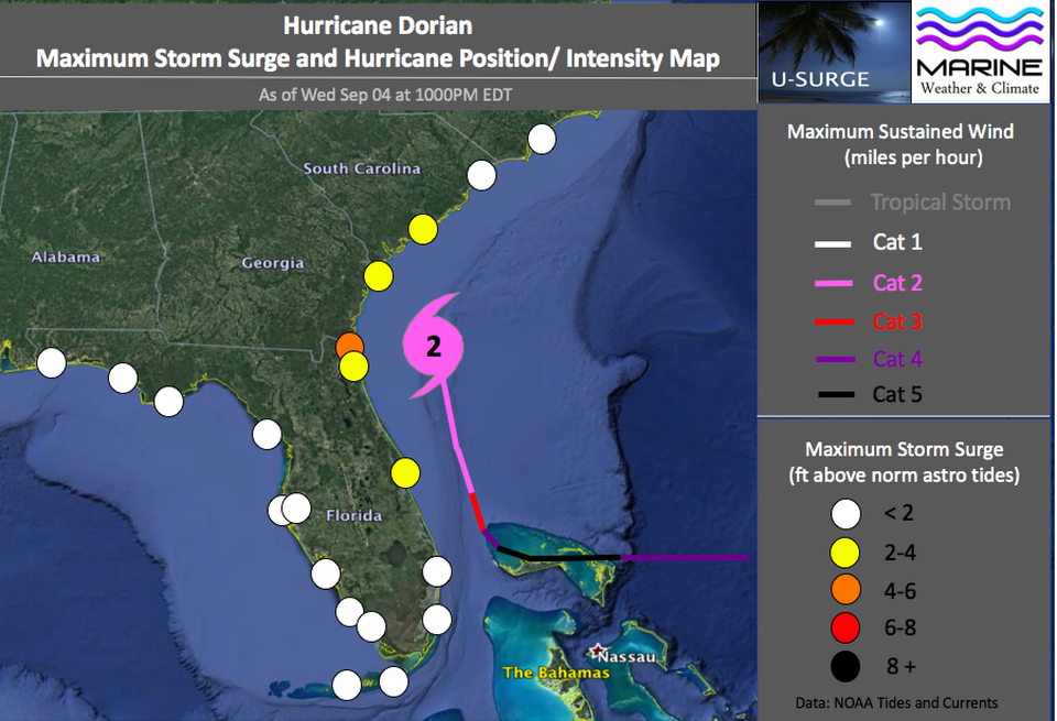
Peak Storm Surge Map as of Wed Sep 04 at 1000PM EDT. Data from NOAA Tides and Currents.
As of Wed Sep 04 at 1000PM EDT, storm surge levels have exceeded 2 feet above Normal Astronomical Tides (NAT) from Florida's Space Coast through approximately Charleston, South Carolina, according to NOAA Tides and Currents Tide Gauges.
The peak storm surge level exceeded 4 feet at one location- Fernandina Beach, Florida, near the Georgia border.
Expect storm surge levels to continue increasing overnight near Charleston and to begin rising more rapidly near Myrtle Beach, South Carolina, and portions of the North Carolina coast.
The peak storm surge level exceeded 4 feet at one location- Fernandina Beach, Florida, near the Georgia border.
Expect storm surge levels to continue increasing overnight near Charleston and to begin rising more rapidly near Myrtle Beach, South Carolina, and portions of the North Carolina coast.