About Palm Beach/ West Palm BeachThe area of West Palm Beach/ Palm Beach is one of the three main metropolitan areas of South Florida, situated nearly 70 miles north of Miami. West Palm Beach contained a population of nearly 100,000 people in the 2010 U.S. Census, while the population of Palm Beach was slightly over 10,000 in the 2000 U.S. Census, but the seasonal population grew to 30,000. West Palm Beach is the oldest municipality in South Florida, incorporated in 1894. Henry Flagler extended the Florida East Coast Railway to Palm Beach in the 1890s, while building the iconic Breakers Hotel, as a destination for tourists.
|
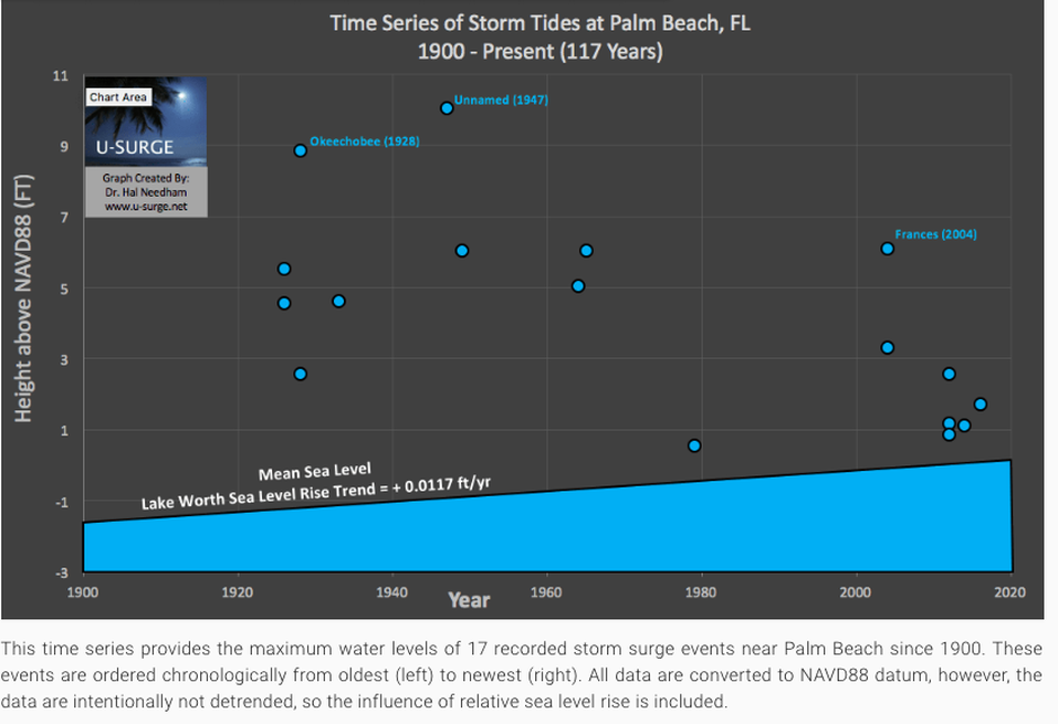
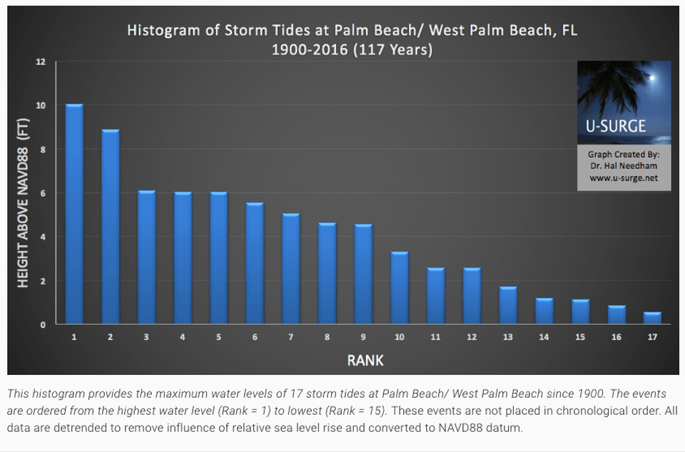
Storm Surge HistoryScientific and historical literature provide 17 storm surge events near Palm Beach/ West Palm Beach since 1900. The 1947 Hurricane produced the most severe coastal flooding, as storm tide levels reached 11 ft (3.35 m) and 51 deaths were reported. A powerful hurricane in 1928, which killed more than 2,000 people when a levee failed at Lake Okeechobee, produced a storm tide of 9.80 ft (2.99 m) near Palm Beach, and inflicted considerable damage on The Hotel Royal Poinciana, which was once the largest wooden structure in the world. This setback was one of several mishaps that struck the hotel, causing the structure to be razed several years later.
|
Infographics
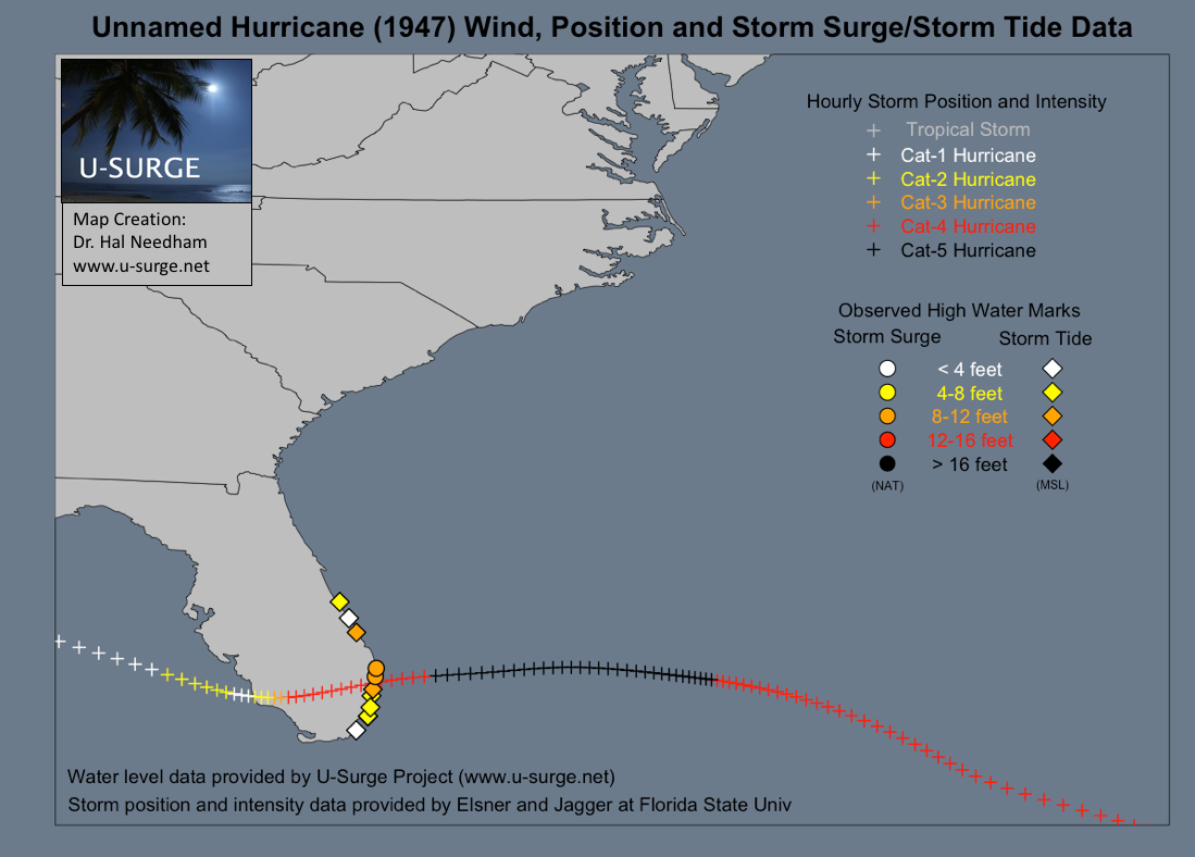
The 1947 hurricane generated the highest storm surge event on record in the Palm Beach County
A category-4 hurricane struck South Florida on September 17, 1947, generating an 11-foot storm surge at Palm Beach, Florida, the highest recorded water level at that location.
Time Series of Storm Surge Flooding in Palm Beach County since 1900
Histogram of Storm Surges in Palm Beach County since 1900
Data Sources
Tide Gauge Data from NOAA Tides and Currents
Lake Worth Pier, FL
Hourly and 6-min Water Level Data from NOAA Tides and Currents
June 17, 2010 - Present
Coordinates: Lat: 26.6022, Lon: -80.0333
Dataset
Hourly and 6-min Water Level Data from NOAA Tides and Currents
June 17, 2010 - Present
Coordinates: Lat: 26.6022, Lon: -80.0333
Dataset
The NOAA tide gauge at Lake Worth Pier provides hourly and 6-min water levels since June 17, 2010.
Link to data site: https://tidesandcurrents.noaa.gov/waterlevels.html?id=8722670
Link to data site: https://tidesandcurrents.noaa.gov/waterlevels.html?id=8722670
Additional
Other Scientific Sources
Other scientific data are provided by multiple sources through the U-Surge Project.
Other Anecdotal Sources
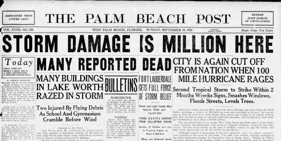
Newspaper archives provided by the Palm Beach Post
Missing Data
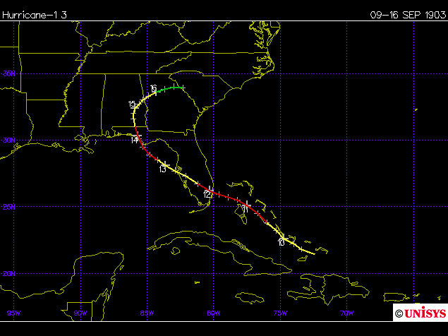
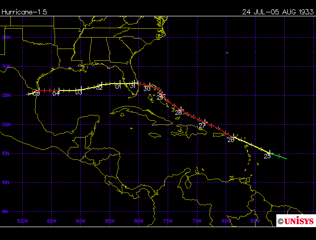
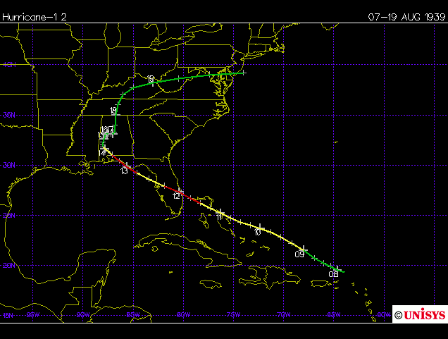
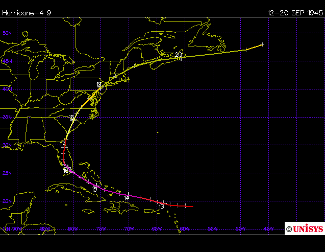
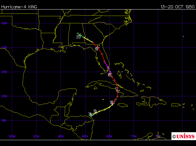
The following hurricanes may have generated storm surges exceeding 4 ft (1.22 m) in Palm Beach County, but a literature review does not yet provide data. We have identified six storms that are missing storm surge data from 1900- present, all of which occurred from 1903-1950. The maps are provided by Unisys Corporation.
Why Palm Beach County Residents
May be Unprepared for Storm Surge Flooding
Article of Interest
by Dr. Hal Needham
Published on the U-Surge Website
Wed Mar 30, 2016
On September 17, 1947, a category-4 hurricane struck southeast Florida, generating an 11-foot storm surge at Palm Beach (Barnes 2007). The sea water at Palm Beach on that date reached the highest recorded level, even topping a 9.8-foot storm tide generated by the "Lake Okeechobee Hurricane" of 1928 (Harris 1963). Both of these storms generated high enough storm surges to inflict substantial damage along the coast.
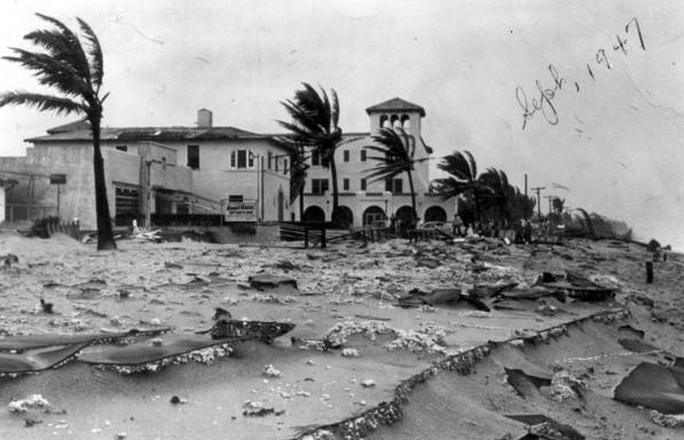
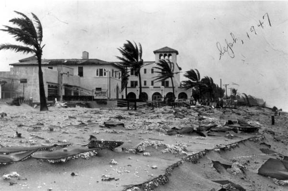
The 1947 Hurricane smashed the coastline of Palm Beach County with a powerful storm surge. This photograph of the Seacrest Hotel in Delray Beach was taken at the northwest corner of Ocean Boulevard and Atlantic Avenue. Image Courtesy: Florida Memory: State Library & Archives of Florida. (https://www.floridamemory.com/items/show/38352).
In fact, since 1926, five hurricanes have generated coastal floods at least 7 ft high in Palm Beach County; this level was reached in 1926, 1949 and 1965, and exceeded by hurricanes in 1928 and 1947. However, all of these events occurred more than 50 years ago, as the area has enjoyed an absence of large storm surges over the past five decades. Why is this?
The absence of large storm surges in this region during recent decades partly has to do with climate and partly has to do with luck, randomness, chance or fortune (pick your favorite term).
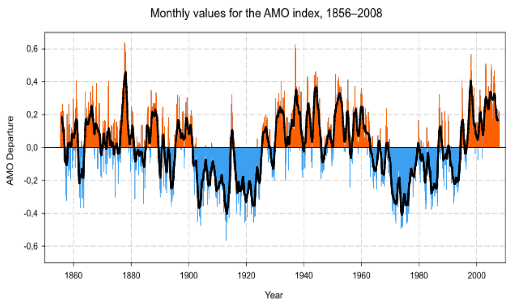
Climatologically, hurricane activity in South Florida was suppressed from around 1968-1994 due to a negative phase in a climate teleconnection called the Atlantic Multidecadal Oscillation (AMO). Climatic teleconnections are links between weather or pressure patterns and resulting weather phenomena, like hurricanes. El Nino is a familiar teleconnection.
The AMO relates to a temperature index of the Sea Surface Temperature (SST) in the Atlantic. When the AMO is in a positive (warm) phase, the SSTs are relatively high and hurricane activity generally increases. When the AMO is in a negative (cold) phase, however, SSTs are relatively low and hurricane activity generally decreases. The AMO was negative from around 1968-1994, meaning there was less activity in those years, followed by a more active period beginning around 1995 (Kossin and Himont 2007).
The AMO Index relates to average sea surface temperatures in the Atlantic Ocean. Negative phases, depicting colder than normal temperatures, occurred between 1900-1925 and approximately 1968-1994. These periods were preceded and followed by warm phases. Image: https://en.wikipedia.org/wiki/Atlantic_multidecadal_oscillation.
However, Hurricanes Hugo (1989) and Andrew (1992) were two major hurricanes that struck the Southeast U.S. during the AMO cold phase, which proves that these teleconnections relate to general correlation, but do not mean there will be an absence of powerful hurricanes.
Randomness also plays a role in hurricane impacts at a particular site, and Palm Beach has been a "lucky" location in recent decades, at least concerning hurricane storm surge.
The 1990s saw Hurricanes Andrew (1992), Erin (1995) and Irene (1999) impact Southeast Florida, but none of these storms generated a substantial storm surge in Palm Beach County because of their their tracks and landfall locations. Hurricane Andrew inflicted catastrophic wind and surge damage in Miami-Dade County, as cat-5 winds and a 16.9 ft storm surge tore through areas south of Miami (Rappaport 1993). However, storm surge levels north of Fort Lauderdale were modest, and typically not even observed. Hurricane Erin made landfall well north of the area, near Cocoa Beach, so the strongest winds in Palm Beach County were blowing offshore. And Irene approached from the southwest, so the water it was pushing mostly impacted the Keys and Everglades.
In the 2000s, hurricanes continued to strike southeast Florida, inflicting the greatest damage on Palm Beach County in 2004. That September, Hurricanes Frances and Jeanne inflicted substantial wind damage on the county. However, since these storms made landfall near the county's northern border, the strongest winds in the area were blowing offshore and suppressing surge levels. Frances produced elevated water levels on the coast, with water levels at Lake Worth Pier reaching 6.3 ft above the NAVD88 datum (Wang and Manausa 2013). Within 10 miles of the Palm Beach/ West Palm Beach area, Jeanne produced a maximum surge of around 3.5 ft (National Weather Service 2010).
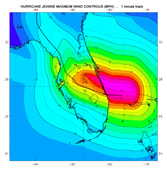
Hurricane Jeanne struck much of Palm Beach County with maximum sustained winds exceeding 70 mph, however, the strongest winds were blowing offshore since Jeanne made landfall north of the area. Due to this track, Palm Beach County experienced substantial wind damage but relatively little storm surge damage. (Note: wind damage was greater in Martin County, to the north.
Image printed in Wang and Manausa (2005).
Image printed in Wang and Manausa (2005).
Several more hurricanes followed in 2005, and although storms like Katrina and Wilma generated substantial wind and rain, their track and intensity were not ideal for generating large storm surges near Palm Beach.
This lack of large surges over more than five decades may leave many residents of Palm Beach County unprepared for saltwater inundations in the future.
Massive population growth in this region will substantially increase storm surge impacts even if future storm surges do not surpass the frequency or magnitude of surges in the past. From 1970 to 2014, Palm Beach County has grown by more than 400%, as the population increased from approximately 349,000 to 1,398,000 (U.S. Census 2014). That's an addition of more than one million people in 45 years.
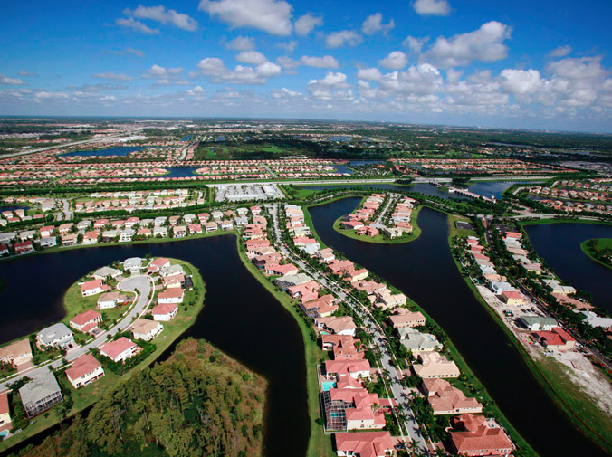
This 2007 arial photo depicts widespread suburban sprawl encroaching on a water-logged area of the northern Everglades in Palm Beach County. Massive population growth in recent decades places more people at risk from storm surge and sea-level rise. Image Courtesy Herald-Tribune Archive/ The New York Times.
Sea level rise has also increased the ocean level in recent decades, meaning a lower magnitude storm surge today could reach the same water levels reached in the 1960s, because the seawater has a head start. Unfortunately, many people along Florida's Atlantic coast may feel that sea level rise is an issue restricted to Miami-Dade and Broward counties, but will not affect Palm Beach County and points north.
Long story short, Palm Beach County is vulnerable to inundation from coastal flooding, but because of climatological factors and a bit of good luck, the area has avoided any substantial storm surges for more than 50 years. Many local residents are transplants who have never experienced a hurricane before, and long-timers likely think of hurricanes as wind events instead of storm surge events, given the history of the past five decades. We can only hope residents realize their luck will run out and salt water will once again inundate their coastal communities.
REFERENCES
Barnes, J., 2007: Florida’s Hurricane History, 3rd Edition, University of North Carolina Press, Chapel Hill, North Carolina, USA, 407 pp.
Harris, D.L., 1963. Characteristics of the Hurricane Storm Surge. United States Weather Bureau, Technical Paper No. 48. Available on the web at: http://www.csc.noaa.gov/hes/images/pdf/CHARACTERISTICS_STORM_SURGE.pdf.
Kossin, J.P., and D.J. Himont, 2007: A More General Framework for Understanding Atlantic Hurricane Variability and Trends. Bulletin of the American Meteorological Society, DOI: 10.1175/BAMS-88-11-1767.
National Weather Service, 2010: Hurricane Jean, Miami- South Florida Weather Forecast Office, Miami, Florida. Available on the Web at: http://www.srh.noaa.gov/mfl/?n=jeanne.
Rappaport, E., 1993: Preliminary Report, Hurricane Andrew, 16-28 August, 1992. National Hurricane Center, Miami, Florida, USA. Link: http://www.nhc.noaa.gov/1992andrew.html.
U.S. Census, 2014: Census of Population and Housing. Link: http://www.census.gov/prod/www/decennial.html.
Wang, R., and M. Manausa, 2005: Hurricane Jeanne, Characteristics and Storm Tide Evaluation, Draft Report. Submitted by Beaches and Shores Resource Center, Florida State University, 11 pp. Link: https://www.dep.state.fl.us/beaches/publications/pdf/tropical/2004/strmtide/jeanne.pdf.
Wang, R., and M. Manausa, 2013: SBEACH High-Frequency Storm Erosion Model Study for Palm Beach County, Final Report. Submitted by Beaches and Shores Resource Center, Florida State University, 52 pp. Link: https://www.dep.state.fl.us/beaches/publications/SBEACH/sbeach-PalmBeach-FinalReport1.pdf.
Related article in the Palm Beach Post from April 1, 2016...
Storm Surge Multimedia
-
Hurricane Frances (2004)
-
Unnamed (1947)
-
Lake Okeechobee (1928)
-
Great Miami (1926)
<
>
The 1947 Hurricane smashed the coastline of Palm Beach County with a powerful storm surge. This photograph of the Seacrest Hotel in Delray Beach was taken at the northwest corner of Ocean Boulevard and Atlantic Avenue. This location in Southern Palm Beach County is outside the 10-mile data selection circle centered on Palm Beach, however, it is included because it clearly depicts substantial storm surge damage on the coast. Image Courtesy: Florida Memory: State Library & Archives of Florida. (https://www.floridamemory.com/items/show/38352).
Note: Although this storm inflicted catastrophic impacts from inland storm surge flooding off Lake Okeechobee, the photos shown below are from coastal locations that observed saltwater surges from the Atlantic Ocean.
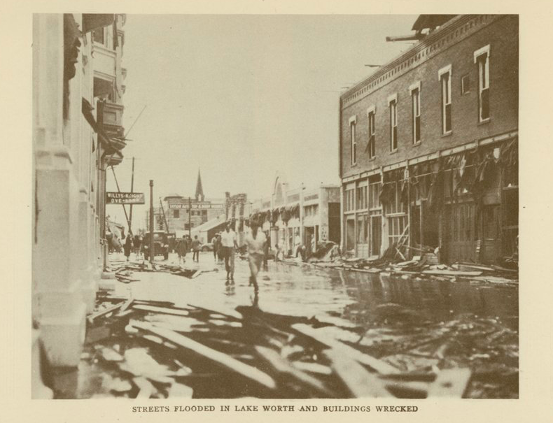
Wind and water damage in Lake Worth. Photo courtesy: National Weather Service Miami - South Florida Weather Forecast Office.
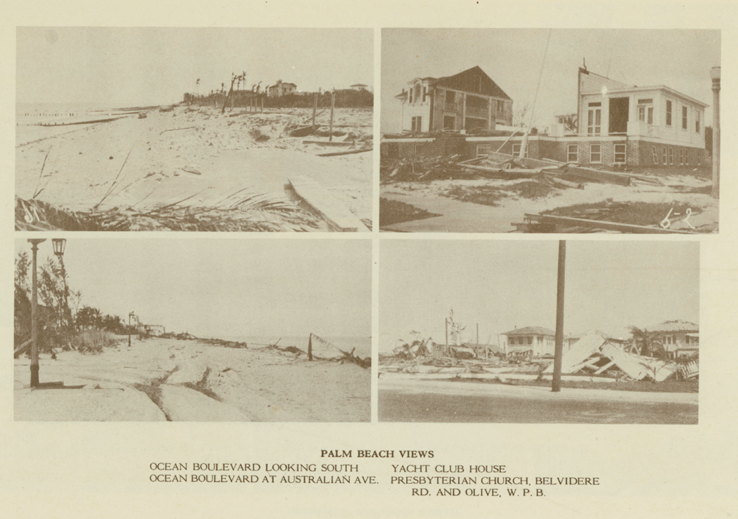
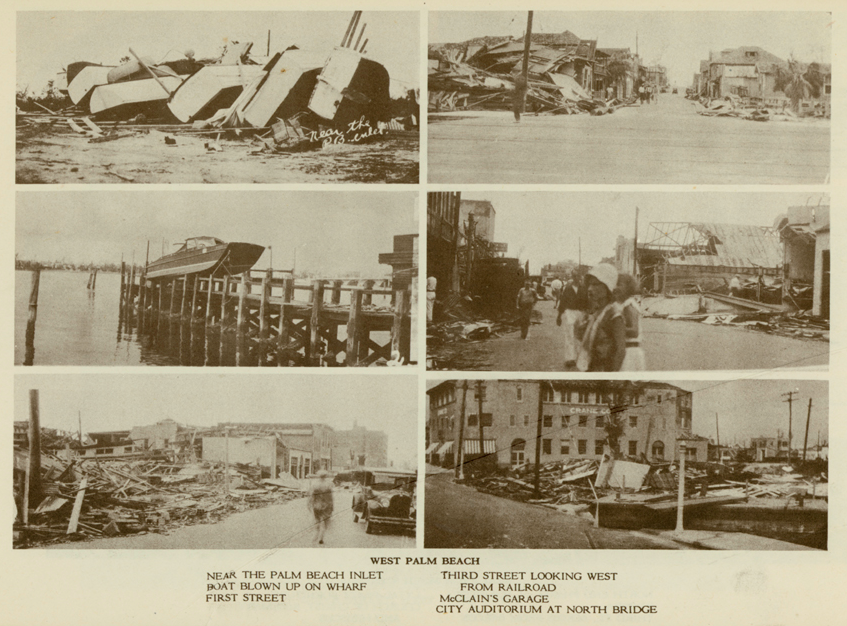
The 1928 Lake Okeechobee Hurricane inflicted considerable damage on Palm Beach and West Palm Beach. The two photos on the left of this image are from ocean boulevard in Palm Beach and primarily depict storm surge damage. Photo courtesy: National Weather Service Miami - South Florida Weather Forecast Office.
These photos show damage in West Palm Beach. The top two photos on the left are from storm surge. The caption of the middle left photo reads, "Boat blown up on wharf," but most certainly storm surge elevated the boat onto the wharf pilings. Photo courtesy: National Weather Service Miami - South Florida Weather Forecast Office.

